



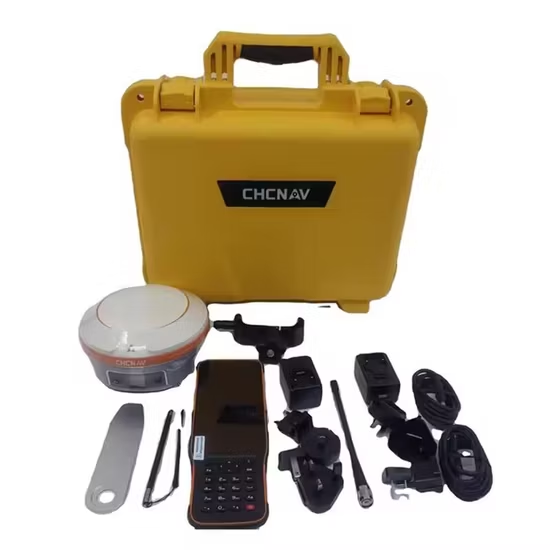
Modern surveying has evolved rapidly with the introduction of advanced satellite positioning systems. Professionals in construction, mapping, agriculture, and infrastructure development now rely heavily on GNSS tools for accurate and efficient measurements. A Complete Overview of Today’s gnss surveying equipment Technologies helps explain how these systems work, the technologies behind them, and why they are essential for modern land measurement.
Understanding GNSS in Modern Surveying
Global Navigation Satellite Systems (GNSS) refer to satellite-based positioning systems that provide location and timing information anywhere on Earth. Unlike traditional surveying methods that rely on line-of-sight measurements, GNSS allows surveyors to collect precise data using signals from multiple satellites.
These systems include major satellite networks such as GPS (Global Positioning System) from the United States, GLONASS from Russia, Galileo (satellite navigation) from the European Union, and BeiDou Navigation Satellite System from China. Together, they provide improved satellite coverage and higher accuracy for surveyors worldwide.
When exploring A Complete Overview of Today’s GNSS Surveying Equipment Technologies, it becomes clear that modern equipment combines signals from these systems to deliver precise geospatial data in real time.
Key Components of GNSS Surveying Equipment
GNSS surveying systems consist of several important components that work together to collect and process positioning data.
GNSS Receivers
GNSS receivers capture signals transmitted by satellites and convert them into location coordinates. Modern receivers can track multiple satellite constellations simultaneously, improving reliability and accuracy.
Antennas
High-quality GNSS antennas are designed to receive satellite signals with minimal interference. They are essential for achieving high-precision results in professional surveying applications.
Data Controllers
Field controllers allow surveyors to manage data collection, view coordinates, and process measurements in real time. Many modern controllers include touchscreens, cloud connectivity, and GIS integration.
Correction Systems
Advanced systems such as Real-Time Kinematic positioning (RTK) provide centimeter-level accuracy by correcting satellite signal errors using reference stations.
Advanced GNSS Technologies in Use Today
As surveying demands increase, manufacturers have introduced several advanced technologies to improve performance and usability.
Multi-Constellation Support
Modern GNSS equipment can connect to multiple satellite networks simultaneously. This increases signal availability and ensures reliable positioning even in challenging environments such as dense urban areas or forests.
Real-Time Data Processing
With RTK and network corrections, surveyors can receive accurate positioning data instantly. This eliminates the need for long post-processing workflows.
Integration with Mapping and GIS
GNSS surveying equipment now integrates seamlessly with geographic information systems. Surveyors can collect, analyze, and visualize data directly in the field, improving project efficiency.
Cloud Connectivity
Many modern GNSS systems allow data synchronization with cloud platforms, enabling teams to collaborate remotely and access updated survey information in real time.
Applications of Modern GNSS Surveying Equipment
Understanding A Complete Overview of Today’s GNSS Surveying Equipment Technologies also requires examining where these tools are used.
Construction and Infrastructure
Surveyors use GNSS to set precise building boundaries, monitor construction progress, and ensure accurate structural alignment.
Land Mapping
Government agencies and private organizations rely on GNSS technology to produce accurate topographic maps and land records.
Agriculture
Precision farming uses GNSS data to optimize planting patterns, irrigation, and fertilizer distribution.
Environmental Monitoring
Scientists and engineers use GNSS systems to track land movement, monitor natural hazards, and study environmental changes.
Benefits of Modern GNSS Surveying Technologies
The adoption of advanced GNSS equipment offers several advantages:
- High accuracy with centimeter-level positioning
- Faster data collection compared to traditional methods
- Improved efficiency in large-scale projects
- Better reliability through multi-satellite support
- Real-time data availability for faster decision-making
These benefits make GNSS technology an indispensable tool for professionals in surveying and geospatial industries.
The Future of GNSS Surveying Equipment
As satellite networks expand and technology improves, GNSS surveying equipment will become even more powerful. Artificial intelligence, automation, and improved satellite signals are expected to further enhance accuracy and efficiency.
By studying A Complete Overview of Today’s GNSS Surveying Equipment Technologies, it becomes clear that GNSS is transforming how land measurement and mapping are performed. Surveyors who adopt these advanced tools can work faster, collect more precise data, and manage projects more effectively.
